Chapter I – INTRODUCTION
I. NECESSITY PROCEEDS PLANNING DEEP WATER PORT IN BAC LIEU PROVINCE
1. Overview
The 9th Congress of the nation has defined: Strategy of economic development – society beginning 10 years of the 21st century is pushing up industrialization and modernization of
the country under socialist orientation, and build the foundation for our country basically become an industrialized toward to modernization in 2020.
Based on the guidelines set forth, the Party and State has directed the construction and development of territories, including South areas in key economic region in Southwest, with a specific orientation: Setting up and promoting the role of the Centre for trade, Exports, Telecommunications, Tourism, Finance, Banking, Science and Technology, Culture, training and boosting Oil and Gas exploration industry, Energy production, Fertilizers and Chemicals from the Oil and Gas; customize and upgrade Industrial Parks, Export Processing Zones, High-Tech Zones; Expand industry in all provinces. Development potential and advantages in geographic location, natural conditions, the infrastructure inventory system builders southwest region in key economic region in the South became one economic region play dynamic, speed up economic growth and sustainable high quality, really a dynamic economic region of the country. To go in industrialization and modernization of the country and in some important areas, contributing to enhancing the quality, efficiency and international competitiveness, to go in the trend of global economic integration, and motivate the development of the South-West region.
According to the plan economic development – economic development of the region, with geographical characteristics and geographic conditions of social economic development, Mekong Delta are assigned to a domain orientation in the southern key economic, acting as a transition intermediate economic region with Ho Chi Minh City, Southern Highlands and other areas in the country. That is the strength and also is major challenge with Bac Lieu provincein particular and the Mekong Delta in general.
2. General introduction of the Mekong Delta
Mekong Delta is well endowed the natural conditions of soils and climate. Mekong Delta River region of Vietnam, also known as southern delta or west short on the southern, or calling by the Southern people of Vietnam is Western short, there are 12 provinces and a city under central Committees including the provinces of An Giang, Ben Tre, Bac Lieu, Ca Mau and Can Tho City, Dong Thap and Hau Giang, Kien Giang, Tien Giang, Soc Trang, Vinh Long, Tra Vinh and Long An.
* Population
According to 2010 census the total population of the Mekong Delta River is 17,272,200 people. Population density ratio of females accounted for 50.2% of the population ratio in urban areas is 23.16%.
Population of labour age in 2010 was approximately 10,128,700 people. Labour rate from 15 years old are employed in the economy have been trained by 7.9%, the unemployment rate of labour force in urban areas 4.08%, The unemployment rate in the labour age in 2010 is
3.45% and 6.35% are underemployed. (Source: Department of Statistics)
* Climate
The equatorial climate is convenient for the development of agriculture (rainy, less sunny), especially rice cultivation and food crops.
* Economic Characteristics
In recent years the Mekong Delta have economic prosperity significant step, the economic structure to shift towards positive (gradually reducing the growth in Region I, Region II and III). Improved People’s life has been increase.
– The total value of regional GDP (in constant prices of 1994) reached VND161,049.3 billion;
– The structure of GDP positive changes: Region I accounted for 34.45%, accounting for
29.23% of Region II and Region III is 36.32%. Economic growth in 2010 reached 11.93%.
– The value of agricultural production (in constant prices of 1994) VND56,078.8 billion, up
4.3% compared to 2009; the industrial production value (at constant prices of 1994): VND79,985.1 billion, up 15:54 % compared to 2009.
– Aquaculture production reached 1,940,181 tons, 1,509,963 tons of farmed fish accounted for 73.35% national fish production. 341,117 tons of farmed shrimp output accounted
75.74% of the country.
– Total retail sales reach whole region 277,487.9 billion (real price), the country accounted for 17.99%.
– Export turnover in the whole region reached: USD6,869.6 million, imports: USD2,523.7 million (Source: Department of Industry and Trade of the provinces in 2010).
– Volume of goods transported by road 1,627.1 million tons, volume of goods transported by waterways 5,291.6 tons, (calculated to 31/12/2009);
– Foreign direct investment licenses granted (cumulative validity of the projects are to
31/12/2010) are 565 projects with USD9,439.9 million In 2010, Mekong Delta has 98 projects licenses granted with USD1,821.5 million.
– Total number of enterprises (companies) are 23,220 enterprises; Number of enterprises with 200 employees is 170 companies; Total number of employees involved in the enterprise are 667,300 female employees accounted for 281,800, Which capital produced an average annual business of the company is VND281,873 billion with the value of fixed
assets and long-term investments of VND231,454 billion (as of 31/12/2009);
– Number of college students and colleges (2010) 139,042 students (6.4% nationwide), with a total of 5,692 teachers (7.6% nationwide)
– Number of telephone subscribers has to 31/12/2010 is 2,290 thousand subscribers.
– The establishment of region clinics facility which is 1,811, 154 Hospitals, 92 Clinics, 2
Nursing homes and Hospital rehabilitation.
3. The necessity investments
Currently the volume of rice exports over 8 million tons of agro-forestry-fishery products over
4 million tons and export goods from factories in Industrial Zones over 3 million tons by waterways. The total exports of goods by waterways present in the Mekong Delta in approximately 11 million tons. All these goods are transported by small vessels or barges backward to Ho Chi Minh City then re-exported overseas. The transportation is very costly so the time.
When refinery capacity comes into operation from 150,000 to 300,000 barrels/day, imports approximately 15 million tons of crude oil, at the same time we also export to a number of petrol, oil and 12 million tons of refinery products.
Additionally, by decision of 1208/QD-Ttg dated 21/07/2011 the development plan of national electricity sector since 2011 – 2020 and 2030 taking 18,000MW such as coal to run for power plants is approximately 20 million tons. Therefore the coal imports are huge need for large port to receive and transit to plants.
The preliminary the volume of goods imports and exports roughly +35 million tons/year in 5 first year and smoothly increasing up to +60 million in 2030.
In year when Deep sea port be finished as Coal port, Oil port, goods port And Industrial Park go working needed goods import, export may increase. Goods is machineries, materials,etc,…
If the waterway open along Mekong River, then the exports goods from Cambodia will follows the Mekong River back to Vietnam.
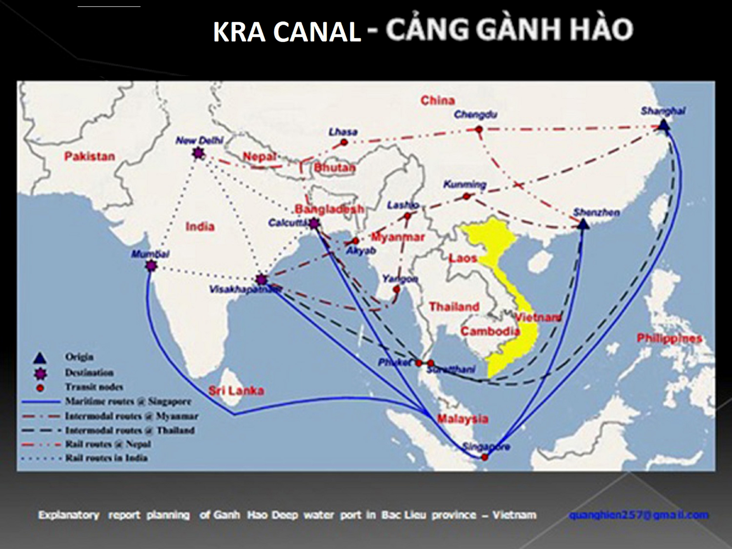
If review of South East Asian region currently in Singapore is overcrowded, have to find a transhipment port to be located in Mekong Delta.
If in latter, to shorten the International Maritime route connected Asia and Europe, there Kra canal in the Strait of East Malaysia and Thailand then Mekong Delta is on the International Maritime route.
Besides, Vietnam today in general and the Mekong Delta in particular, but also very redundant ports, ports lack sufficient international standards allow vessels with a tonnage
100,000DWT flow. Therefore the construction a multi-purposes port complex to international standards in the Mekong Delta with full associated services, increase is feasible because of economic and social advantages will make use the nature of young labour force.
4. Location selection
By comparison with many localities in the Mekong Delta area, along with survey results of the exploration missions in the 1990s by France group and the United States group in 2000, the Soc Trang and Bac Lieu provinces are convenient for planning sea port. With the natural advantages of climate and river water then we decided to select Ganh Hao, Bac Lieu province as investment location, land scale large enough for planning. The planning area has low population, planning should not disturb affecting social and economic life in the locality. Besides Bac Lieu province for 50 years not yet suffer of storms, so convenient for investment in building a deep water ports here.
II. LEGAL BASIS OF PLANNING GENERAL AREA OF GANH HAO ECONOMIC MARINE ZONE
1. The legal basis
– DECISION OF PRIME MINISTER :THE MASTER PLAN APPROVED SOCIAL- ECONOMIC DEVELOPMENT OF BAC LIEU PROVINCE 2020
– Official document number of the government office 406/VPCP-QHQT dated 24/01/2003 about research, construction of deep water port in the area of Bac Lieu province.
– Official document of the Vietnam Maritime Bureau number 1507/CHHVN-KHDT dated
04/10/2002 endorses for foreign investors research, construction investment policy follows the BOT form in the Bac Lieu province.
– Official document by the Ministry of Transport number 5574/BGTVT-KHDT dated
15/09/2006 of survey in reporting feasibility of sea port in Bac Lieu province.
– Official document of the People’s Committee of Bac Lieu province number 886/UBND- XDCB dated 03/07/2007 comes to investment in multi-purposes sea port, petroleum/oil
port and refinery in Bac Lieu province.
– Official document of the People’s Committee office Bac Lieu province number 429/VP- XDCB dated 15/09/2007 comes to permit allowing re-survey locations building multi- purposes port, petroleum/oil Port and refinery in Bac Lieu province.
– Official document by the Ministry of transport number 477/BGVT-KHDT call for investment to Bac Lieu province.
– Official document of the Ministry of Planning and Investment number 566/BKH-DTNN
dated 23/01/2008 call for investments in a number of major projects across the province.
2. The applicable rules
– Construction Law number 16/2003/QH11 has the 11th National Assembly of socialist
Republic of Vietnam, the 4th session pass through dated 26/11/2003;
– Decree number 16/2005/ND-CP dated 07/02/2005 of the Government’s Project
Management investment of construction works;
– Decree number 08/2005/ND-CP dated 01/24/2005 of the Government’s construction plan;
– Collection Regulations and construction standards in Viet Nam;
– Vietnam Standard (TCVN4616-88) Planning the Layout of industrial clusters;
– Circular number 15/2005/TT-BXD dated 19/08/2005 of the Ministry for Construction guiding the formulation, evaluation, approval construction plan;
I. LOCATION
Chapter II – NATURAL CONDITIONS

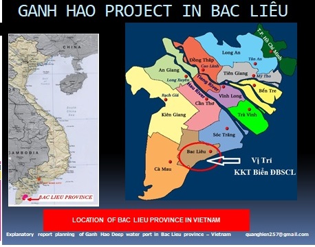
Bac Lieu province located in the western of South region, the regional Mekong Delta, with coordinates from 9°00’00” to 9°37’30” North latitude and from 105°15’00” to 105°52’30” longitude east, distance to Ho Chi Minh City is 280km (to the north). Northern bordering of Hau Giang and Kien Giang provinces, eastern and north-eastern bordering Soc Trang province, west and southwest bordering Ca Mau province, east and southeast bordering China Sea.
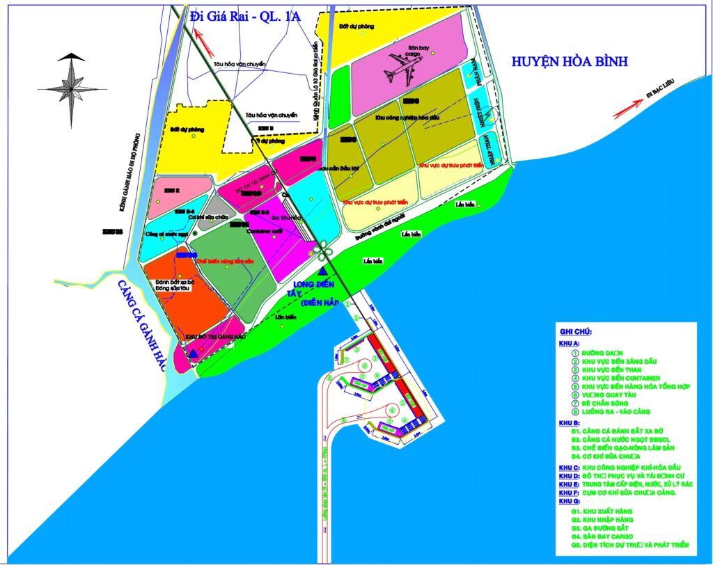
Location of trenches to Ganh Hao economy with a proposed development plan area is 24,300 hectares which are part of Long Dien West, Long Dien East Commune and the whole Dien Hai, Dong Hai districts. Deep water port located in a part of Long Dien West and part Dien Hai Communes.
II. NATURAL CHARACTERISTICS
1. Topography and Geomorphology
Flat, no hills or mountains there are not major shocks geology. The topography is basically plains with vast plains, rivers, canals and interlaced canal.
2. Climate, Hydrography
Bac Lieu province is located in a tropical monsoon climate; the weather is divided into 2 distinct seasons: Dry season (sunny season) starting from October to December last years until April to May next years; rainy season begins April to May until October to November. And especially over 50 past years had not any storm and tsunami as well.
The annual average temperature of 28.5°C, the annual lowest temperature is 21°C in the year (in rainy season), the annual highest temperatures is 36°C (in the sunny season).
3. Geological Engineering
According to the results of geological survey in the area of planning, structural geology of the project construction zone mainly phosphate stones set Leterit condition, with
compressive strength of 1.5kg/cm2 is suitable land for construction.
4. Natural Resources – Minerals
– Forest resources, animals and plants: Bac Lieu province forest of mangrove ecological systems such as Cajuput, Dates, Beansprout etc… Below is the vegetation consists of grass and vine species. According to the Institute for Tropical Biology, Bac Lieu province has 104 forest plant species, 10 species of small mammals, 8 reptiles etc…
In addition, Bac Lieu province has a Wild Bird Garden (area over 30 hectares) in Hiep Thanh Commune, apart Bac Lieu town by approimately 3km (east); 2 gardens in the Phuoc Long and Vinh Phu West towns (Phuoc Long district); a bird garden with rare species of Giang sen of Dong Hai district. especially, Bac Lieu Bird Garden is the largest bird park in the province with more than 40 species of birds, they are more than 60,000 birds, including many types such as Cork, Cannibal, Wild Duck, Wild Stork, White Stork, Giang Sen, Cormorant, Snipe, High Snail, Heron Sunatra etc…
– System of rivers and streams: Bac Lieu province has the river and stream system, canal interlace, basically divided into two groups:
Group 1: Outflow to the south, including Ganh Hao River (length 55km) canal has the
branches are Giong Ke, Lo, Nha Tho, Cai Keo, Goc etc…; My Thanh River (length
70km) canal has the branches are Le, Bac Lieu, Tro Nho, Tra Nieu and Tra Teo, Bac Lieu canal length 35km.
Group 2: Outflow to Ba Thac River (often called the Hau River, Hau Giang). This group includes Ba Xuyen canal and the small branchs of the canal Ba Xuyen.
The Canal: To remove the alum for production and transportation needs for the period 1901
– 1903, the colonial authorities had dug channels Quan Lo – Phung Hiep length 140km, the Bac Lieu – Ca Mau length 48.5km. By 1915, the colonial government to dredge the canal expansion Bac Lieu – Ca Mau (length 66km) and expand digging canal Bac Lieu – Co Co (length 18km). After the First World War (1914 – 1918), the colonial government continued land exploitation Bac Lieu area with larger scale: in 1920, dig canal Hoi Phong – Chu Chi – Cho Hoi (length 29km) and channels Gia Rai – Pho Sinh – Canh Den (length 33km) year 1925, dig canal Lo Be – Ganh Hao length 18km; year 1931 dig canal Xom Lung – Cong Cai Cung (length 13km), canal bridge No. II – Phuoc long (length 24km) and Canal Cau Sap – the Intersection of Vinh Phu – Ngan Dua (length 49.5km).
Sea Bac Lieu province has coastline of 56km. Bac Lieu province has many species of marine shrimp, fish, snails, blood clams etc… Every year, output reached 100,000 tons of fish, shrimp. in which close to 10,000 tons of shrimp. Low, flat coast is suitable for development of salt production, cultivation or farming of shrimp, fish. Every year, the compensation in Bac Lieu polders increasing. These are ideal conditions for further development Bac Lieu province land, same time is the important element to the maritime economy development of Bac Lieu.
5. Landscape and Environment
Coastal area of Dong Hai district, sea water muddy more alluvium, shallow seashore, not in regional tourism planning of Bac Lieu province. But the land rich terrain areas can build services for industrial zones and residential areas.
Chapter III – CURRENT PLANNING AREA
I. CURRENT LAND USE OF PLANNING AREA
Dong Hai is a districts of Bac Lieu province, is separated from the Gia Rai district in 2002. The district has potential economic development, especially fisheries, marine tourism is also
a potential, in addition to salt etc… However, current above potentials have not been exploited effectively.
Dong Hai district has 57,008.74 hectares natural area and population of 145,434, has 11 units directly under District Administrative, including Ganh Hao towns and communes of Long Dien, Long Dien East, Long Dien East A, Long Dien West , Dien Hai, An Phuc, An Trach, An Trach A, Dinh Thanh and Dinh Thanh A.
Currently the land area used for aquaculture at approximately 15 – 20% of the total land area is expected to plan most of the remaining vacant land and coastal protection forest.
II. CURRENT POPULATION AND LABOUR BASIS ECONOMIC – TECHNICAL
1. Population
The district has 145,434 inhabitants distributed but concentrated in the Ganh Hao town.
– Ethnic majority is Kinh.
– The average population density of 225 people per km2.
– The rate of natural population increase average is 1.6% in year 2011. People at working age are common agricultural labour accounting for approximately 85%.
2. Basic of Economic and Technical
– Economic structure of the district is agriculture – forestry – fishery: 62%; industry and construction: 16%; Commercial – Services: 22%, an average annual increases over 10% of district economic growth.
Dong Hai district has the largest coastline in Bac Lieu province, the district’s economy also relies heavily on the sea. The people of the Dong Hai district traditional pruduced salt, farming fishes and shrimps. In year 2011, Dong Hai district, Bac Lieu province have 573 facilities of exploitation of marine products, which is 232 units capable of offshore fishing, with average annual output of 40,000 tons. District aquaculture area is 38,457 hectares, accounting for 67.5% of the natural area. With an average output over 40,000 tons per annum.
Dong Hai is the largest salt producing districts of Bac Lieu province, where the salt supply of raw materials for manufacturing plants within and outside the province. The district has more than 2,188 hectares of salt production areas, accounting for 3.8% of the natural area. The total forest area in the district is 2,308 hectares, accounting for 4.1% of the natural area. Dong Hai forest is coastal forest, it has less valuable for timber, but there are important protective function because it is coastal forest, coast with erosion, breakwater etc… Protect the environmental and ecological role in the combined aquaculture. Also strengths is the exploitation and for aquaculture, there are 2 rice- growing areas in districts with focus Long Dien East and Long Dien East A, with an area of
948 hectares of natural area.
– Trade – Services: The district currently has 4,086 commercial business bases – services,
11 cooperatives with 1,933 cooperative members, the total charter capital of approximately VND3.6 billion with these primarily line of business: aquaculture, salt production, animal husbandry and services etc…
– Industry and handicraft: has 1291 establishments producing industrial – handicraft with major sectors such as ice producers, mechanical repair and processing of seafood, food processing, food, salt production, machining, most of these establishments produce effective business. But the scale and level of investment does not meet development needs, primarily processing and rudimentary process, without the modern platform of industry.
III. CURRENT STATE OF ARCHITECTURE – CONSTRUCTION
1. Current state of Production projects
– The district currently has 4,086 commercial business bases – services, 11 cooperatives with 1,933 cooperative members.
– 1,291 establishments producing industrial – handicraft.
2. Current state on Housing constructions
– 75% of the district housing which is the brick approximately 35% is the house level 4 is the remaining level 2 and 3.
– 25% of thatched house and the tabernacle.
3. Current situation of Public project constructions
The district has a District Cultural Centre and all the communes have the Cultural Social
House at its owned.
4. Current state of Other architectural
Giac Ngo Ganh Hao Temple.
IV. CURRENT STATE OF TECHNICAL INFRASTRUCTURE
1. Current state of Traffic roads
– The Districts have 10/11 communes, townships has road traffics to the centre
– 84/84 hamlets have rural road traffics hamlet linked hamlet.
– 2011 construction new and repair 36 routes and 67 bridges.
– In 2012 construction 59 new bridges of rural traffics.
2. Current state of Power grid
In the planning area has an 110kV power line cross.
3. Current status of Telecommunications
– The Telecommunication System is only coverage on the river side nearby to the
Commune centre, density of subscribers approximately 20 lines/hectare.
4. Current state of Water supply and Drainage
– Water supply: Currently no regional water supply systems
– Drainage: Currently areas no regional drainage system, the natural terrain sloping toward the canals, rivers than water naturally discharged through the sewer system.
Chapter IV – ORIENTATION THROUGH THE PLANNING PHASE
I. REGIONAL RELATION TO GANH HAO ECONOMIC MARINE ZONE
Ganh Hao Economic Marine Zone has location and the relationship area: The area in connection with the highway Quang Lo – Phung Hiep districts; to Ca Mau, Can Tho provinces etc…


II. EXPLOITATION POTENTIAL CONSTRUCTION LAND AREA OF GANH HAO ECONOMIC MARINE ZONE
Ganh Hao Economic Marine Zone may extend southward to the sea for building port and other
projects.
Economic Marine Zone conjugate could expand westward on the east and northward because vacant land is quite a lot.
III. GENERAL PLANNING OF GANH HAO ECONOMIC MARINE ZONE
MASTER PLAN
Ganh Hao Economic Maritime Zones – Bac Lieu province been planned following the trends to open with 50 – 70 years vision includes the segments as follows:
- THE REQUIREMENTS FOR INVESTMENT
Bac Lieu province natural position convenient to fifty six (56) km along the coastline, be blessed on climate (last fifty (50) years Bac Lieu does not have a storm). Road and river traffics through the area surrounding provinces Mekong Delta is very convenient. Circumferential radius of three hundred (300) km by sea, if applied to goods trading, Bac Lieu province covers all countries in the region: Thailand, Singapore, Laos, Cambodia etc.. The total agricultural exports in the Mekong Delta region are enormous: Rice export volume is over six (6) million tons / year and other staples than one (1) million tons/year; Amount of seafood over two (2) million tons. So far all the goods exported are shipped to Ho Chi Minh City and then export to the destinations, thus the cost of expensive and time-consuming transit. For these reasons, investment in deep sea port in the Mekong Delta region, especially with above conditions, investment in Bac Lieu province is feasible.
- PROJECT SCALE AND INVESTMENT ITEMS
Marine economic zone project at Ganh Hao, the scale project is around twenty thousand nine hundred sixty seven (20,967) hectares, marine economic development strategy not only for Bac Lieu province, but also important for the Mekong Delta provinces. The project was built with 10 items (portfolio) is planning a harmonious, modern environment-friendly include:
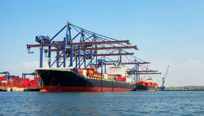
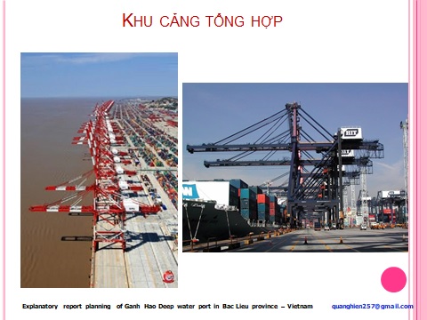
- 1/- Deep sea port with a tonnage of one hundred (100,000) tons, including petroleum port – for refineries in the economic zone Ganh Hao; Coal port to service for thermal power plants of three thousand six hundred (3,600) MW in Bac Lieu province; Four thousand two hundred (4,200) MW in Soc Trang Province and the Mekong Delta development plan in year 2020 to the entire power demand. Mekong River Delta will build fourteen thousand (14,000) MW of power plant to meet the demand for electricity for production and living activities.
- The preliminary the volume of goods imports and exports roughly +25 million tons/year in 5 first year and smoothly increasing up to +60 million in 2030.
- In year when Deep sea port be finished as Coal port, Oil port, goods port And Industrial Park go working needed goods import, export may increase. Goods is machineries, materials,etc,…
- If the waterway open along Mekong River, then the exports goods from Cambodia will follows the Mekong River back to Vietnam.
- If review of South East Asian region currently in Singapore is overcrowded, have to find a transhipment port to be located in Mekong Delta.
- 2/- Power Plant of three thousand six hundred (3,600) MW operational combination of energy sources such as coal, gas and diesel.
- 3/- Fish Ports to service the Pacific fishing fleet of the United States and Russia with over five hundred (500) fishing boats and other domestic and abroad.
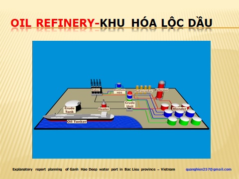
- 4/- The Refinery and Petroleum storage.12,000,000 MT /years
- 5/- Agricultural and Seafood Processing Zone – (Processing Park), including cold stores, production of ice factory, processing plant etc… The recycling service for the Pacific fishing fleet.
- 6/- Marine Aquaculture Zones: Currently aquaculture area greater then one hundred twenty thousand one hundred and seventy four (120,174) hectares in Bac Lieu province but they are not in a focus area and weak in farming techniques, so economic efficiency is low, can not meet export requirements. Therefore there should be a focus area of research and breeding.
- 7/- New shipbuilding and repairing ship plant
- 8/-Fertilizer plant and products for aqua-agriculture plant
- 9/- Concentrated Industrial Zones: The manufacturing industry focus in an industrial zone to facilitate the productions and businesses (near the raw material plant) with the power system for 24/24 supplied, complete export and import services, low land rentals, waste disposal system for the whole area and simple investment procedures through the Industrial Zone Management.
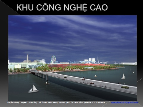
In addition to focusing on the development of High Technology Zones.
- 10/-Port City Park:
With all necessary facilities such as: Business Centre Services: Supermarkets, Restaurants, Hotels, Entertainment amusement etc… - Office tower.
- Residential Areas: Professional, Relocation, Workers housing etc…
- Campuses: From kindergarten to university.
- International General Hospital.
(Which is studying building design of Bac Lieu province icon).
Environmental Treatments: All sewage and garbage will be processed for re-cycle by modern technology (Plasma Technology application for waste and hazardous waste).
11.Domestic Airports and Cargo: When the economic zones and the plants operated travel are needs of investors and tourists, so as the domestic airport investment is reasonable. Besides, is great demand for cargo transportation by airway, currently Cargo Airport not available in Asia.
- TOTAL INVESTMENT CAPITAL (provisional)
Total investment for the project estimated in between ± USD21 billion including:
- Site clearance compensation and Resettlements Costs: 20,967 hectares x 10,000 x USD10/m² = USD 2.967.000.000.
– Construction of internal roads and connects with the main axist: USD 2.5 billion estimates
– Construction per items of the project costs:
- Power Plant 3600MW: USD 3,600,000,000 estimates
- Deep sea port of one hundred thousand (100,000) tonnage DWT: USD 1,500,000,000 estimates
- Cargo Airports: USD 500,000,000 estimates
- Oil refinery and petroleum storage: USD 3,500,000,000 estimates
- Industrial Park: High technology, Seafood products processing zones: USD 2,000,000,000 estimates
- The City Port: Residency, Supermarket, Hospitals, Schools, Entertainment centre, Hotels etc… USD 4,000,000,000 estimates
– Survey and Design costs: USD 20,000,000 estimates
– Management and administration, building office and residential areas for specialists Costs: USD 200,000,000 estimates
– Provisions of charges: 10% estimates
CHAPTER V – CONCLUSIONS
With huge economic potential in Mekong Delta, invest to A sea port economic system of multi-purpose Deep sea port in Ganh Hao, Bac Lieu province is essential, Bac Lieu sea port not only holds important positions in the Southern waters on economic, security and defense, but also create a driving force for the growth of other economic sectors. Also give Ganh Hao became the centre of maritime transport services and transshipment goods, creating a linkage in the transportation and exchange of goods in the region of the province and the country, an important contribution in the fulfillment goods and comprehensive system of transportation in the region.
